East Yorkshire roadworks: Temporary 20mph speed limits to be enforced on roads during £3.5 million project in Yorkshire to help reduce risk of potholes

East Riding of Yorkshire Council is investing the money in its annual surface dressing programme, which is due to start on April 16, 2024, and is expected to take 13 weeks to complete, depending on weather conditions.
The programme will cover all types of roads, from A roads to unclassified roads and it will upgrade 139 sections of road in the area - around 69 miles in total, which is the same as a straight road from Beverley to Hartlepool.
Advertisement
Hide AdAdvertisement
Hide AdAround 13,400 tonnes of stone chippings will be laid on road surfaces during the spring and summer operation.
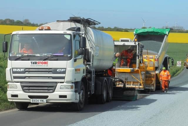

Surface dressing is a fast and cost-effective way of fixing, preserving and extending the lifespan of a road, and it is taken place every year by the council’s own highways maintenance team.
The work entails applying hot, adhesive bitumen on the road, covering it with chippings and then rolling them in.
Following on from that, road sweepers clear away any loose chippings after a few days and new road markings are put down as quickly as possible.
Advertisement
Hide AdAdvertisement
Hide AdThe process actively reduces the risk of potholes forming as it seals the road and stops water from entering and damaging the surface. It also greatly enhances skid resistance for vehicles.
The process is carried out during the spring and summer months as it requires warmer temperatures for the bitumen and chippings to take effect.
Residents and drivers will be notified before the works begin; a leaflet will be sent to all residents who will be impacted by the roadworks and advance warning signs will be posted on the roads before the works begin.
During and after the work temporary 20mph speed limits will be in force on the treated roads to reduce the possibility of vehicles skidding on the loose chippings and will be removed when the new road markings have been installed.
Advertisement
Hide AdAdvertisement
Hide AdDisruption to traffic will be kept to a minimum, but drivers are asked to respect the 20mph speed limit that will be enforced to protect both the travelling public and the council’s workforce.
Following the completion of the surface dressing, any loose stone chippings left behind won’t go to waste.
Mechanical road sweepers are used to collect all the loose chippings which are then stored and every two years the council hires a giant industrial washing and grading machine to clean up all loose chippings so that they can be recycled and reused on the roads the following year.
The process recycles more than 7,000 tonnes of chippings and saves around £60,000 of council tax payers’ money.
Advertisement
Hide AdAdvertisement
Hide AdDifferent roads are chosen for surface dressing every year across the East Riding of Yorkshire, from those needing the most attention.
Coun Paul West, the council’s cabinet member for environment and transport, said: “Our annual surface dressing plays a vitally important role in protecting the East Riding's roads and defending against potholes and other damage.
“Our teams will be working in more than 100 locations across the area this spring and summer and we'd like to thank residents and motorists for bearing with us while this work is carried out.”
Below is a list of the roads that will be affected by the project
Advertisement
Hide AdAdvertisement
Hide AdEast Yorkshire roads to be affected by £3.5 million surface dressing project
Flamborough Road, Bempton
Gillus Lane, Bempton
High Street, Bempton
Newsham Hill Lane, Bempton
Hatkill Lane, Bishop Wilton
Fortyfoot, Bridlington
Kingston Road, Bridlington
Queensgate, Bridlington
Scarborough Road, Bridlington
Main Street, Buckton
Newland Avenue, Driffield
Chapel Street, Flamborough
North Marine Drive, Flamborough
Woodcock Road, Flamborough
Hatkill Lane, Full Sutton
Boynton Lane, Grindale
Merside, Grindale
Harpham Lane, Harpham
Manor Farm Road, Kirkburn
Scarborough Road, Nafferton
Main Street, North Dalton
North Dalton Road, North Dalton
Main Street, Ruston Parva
Moor Road, Stamford Bridge
Kilham Lane, Thwing
Seamer Road, Thwing
Main Street, Warter
North Dalton Road, Warter
Road between Dalton Road and Huggate Road, Warter
Main Street, Wetwang
York Road, Wetwang
Oakfield Avenue, Barmby on the Marsh
South Street, Barmby on the Marsh
Station Lane, Barmby on the Marsh
Stocks Lane, Barmby on the Marsh
Green Lane, East Cottingwith
Langrickgate, East Cottingwith
Red Cap Lane, East Cottingwith
Whitegate Lane, East Cottingwith
Chiltern Road, Goole
Western Road, Goole
High Street, Holme on Spalding Moor
Market Weighton Road, Holme on Spalding Moor
Applegate, Howden
St Johns Street, Howden
St Peters Close, Howden
Orchard Close, Pocklington
Orchard Gardens, Pocklington
Orchard Way, Pocklington
Sherbuttgate Road North, Pocklington
Southfield Court, Pocklington
St Johns Close, Pocklington
Westfield Close, Pocklington
Westfield Road, Pocklington
Towthorpe Lane, Shiptonthorpe
Willitoft Lane, Wressle
Aike Lane, Aike
Chapel Lane, Aike
Armstrong Way, Beverley
Dog and Duck Lane, Beverley
Flemingate, Beverley
New Walkergate, Beverley
Ropery Close, Beverley
School Lane, Beverley
Spencer Street, Beverley
Walkergate, Beverley
York Road, Beverley
Dog Kennel Lane, Bishop Burton
Fisher Street, Etton
Aike Road, Lockington
Front Street, Lockington
Station Road, Lockington
Heater Corner to Cow Bridge, Lund
Heater Corner to Middleton Road, Lund
Alpha Avenue, Molescroft
Danesway, Molescroft
Pighill Way, Molescroft
Saxon Rise, Molescroft
Woodhall Park, Molescroft
Woodhall Way, Molescroft
Beverley Parklands, Woodmansey
Hull Road, Woodmansey
Minster Way, Woodmansey
The Glen, Woodmansey
Woodmans Way, Woodmansey
Beverley Road, Anlaby
Springfield Way Access Road, Anlaby
Burrill Lane, Brantingham
Ellerker Road, Brantingham
Main Street, Brantingham
The Green, Brantingham
Heads Lane, Hessle
Brough Road, South Cave
Jarrett Hills Lane, South Cave
Market Place, South Cave
Station Road, South Cave
Stonepit Lane, South Cave
Beverley Road, Walkington
The Parkway, Willerby
Hornsea Road, Atwick
Skipsea Road, Atwick
Beverley Road, Beeford
Skipsea Road, Beeford
Bridlington Road, Brandesburton
Pinfold Lane, Burstwick
Main Road, Burton Pidsea
Riston Road, Catwick
Rowpit Lane, Catwick
Hull Road, Coniston
Northfield Road, Coniston
Lanbwath Lane, Ellerby
Fieldend Lane, Elstronwick
Magdelengate, Hedon
Souttergate, Hedon
Holmeton Road, Hollym
Manor Lane, Hollym
Brook Drive, Hornsea
Greenacre Park, Hornsea
New Road, Hornsea
Lelley Road, Humbleton
Griffiths Way, Keyingham
Melville Close, Keyingham
Russell Drive, Keyingham
Saltaugh Road, Keyingham
Catwick Road, Long Riston
Rise Lane, Long Riston
Chapel Lane, Ottringham
South End Road, Ottringham
Station Road, Ottringham
High Street, Patrington
Staithes Road, Preston
Wyton Road, Preston
Rise Lane, Rise
Beeford Road, Skipsea
Hornsea Road, Skipsea
Hull Road, Skirlaugh
Main Road, Skirlaugh
Comment Guidelines
National World encourages reader discussion on our stories. User feedback, insights and back-and-forth exchanges add a rich layer of context to reporting. Please review our Community Guidelines before commenting.