Online map plots location of every air raid on Britain during Second World War


The semi-industrial suburb in the West Riding, 10 miles north-west of Leeds and famous for turning out Silver Cross prams, was a world away from the heavily-bombed Yorkshire concentrations around Sheffield and Hull, strategic for steel and shipping.
But it was nevertheless one of the 30,000 pins on the Luftwaffe map which defined life – and often death – on the home front.
Advertisement
Hide AdAdvertisement
Hide AdThe 6,500 pages of daily reports from wartime intelligence officers chronicled every one, but only now are the details being made readily available, in an online map that makes finding an air raid site as easy as searching for a supermarket.
The project, the work of a University of York researcher, is being launched to mark the 80th anniversary today of the first air raid of the war, in the Firth of Forth outside Edinburgh.
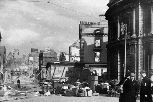
Like the attack on Guiseley, there were no casualties that time. But over the next five and a half years, some 60,000 civilians were killed and another 139,000 wounded.
The map reveals that the Luftwaffe dropped some 580 bombs on the area around Hull, and a further 688 along the coast, from Scarborough down to Skegness.
Advertisement
Hide AdAdvertisement
Hide AdThe biggest concentration by far was in the south and east, with Liverpool also sustaining heavy bombardment.
But less densely populated areas were not immune to attack, with an injury reported at Leyburn in the Yorkshire Dales, on the night before New Year’s Eve, 1941.
Dr Blomvall said the statistics should not overshadow the human tragedy the raids represented.
“There is a story behind each and every bomb. People lost their partners, their children or their homes,” she said.
Advertisement
Hide AdAdvertisement
Hide Ad“Bombs were dropped from the Orkney Islands to Coventry, from Liverpool to the Scilly Isles and from Dover to Swansea.
“The normalisation of aerial warfare turned mainland Britain into a violent battlefield, and the term ‘home front’ was no longer figurative.”
The map offered an “astonishing insight” into the scale of total war and its effect on the population, she added.
The attack on Guiseley – possibly targeted for the presence of the Crompton Parkinson light bulb factory, which was turned over to munitions work – was recorded in a note from an ARP warden in Bradford.
Advertisement
Hide AdAdvertisement
Hide Ad“If they were intended for Yeadon, it was a bad miss, but it made people sit up,” he wrote.
Dr George Hay, at the National Archives, said the map would be “a fantastic resource, not only for military and social historians, but for anyone interested in the impact of wartime air raids across the UK.”
The first bombs were dropped one month and 13 days after Britain declared war on Germany. The Blitz – the most concentrated period of almost nightly bombing – lasted for eight months from September 1940, with the final air raids as late as March 1945.
To produce the online map, Dr Laura Blomvall at the University of York had to manually transcribe 16 volumes of scanned documents. It can be viewed at warstateandsociety.com.