Archaeologists closer to finding settlements of ancient hunter gatherers lost under North Sea after early stone tool discovered off Great Yarmouth
Prof Vince Gaffney from the University of Bradford has spent 15 years mapping Doggerland - which was flooded by a tsunami in 6,200 BC - and once connected Britain to the Continent.
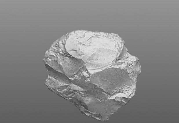
The stonehammer, used for making other implements, was scooped up in a dredge after researchers pinpointed a likely site for human activity on what was once a promontory of the Southern River, which flowed to the sea 10,000 years ago.
Advertisement
Hide AdAdvertisement
Hide AdTonnes of prehistoric bones have been brought up in trawl nets, however artefacts are still very rare, and until now they have only been discovered by chance.

The team hopes to return to the site next year.
"It really is a new world out there," Prof Gaffney told The Yorkshire Post, predicting: "Within a short while we will be finding prehistoric settlements under the North Sea."
An international team was involved in the research aboard a Belgian military boat, but hit bad weather, so they only had a short time in the area, 40 km off East Anglia.
"Of all the places we'd looked at in the southern North Sea this was the one that we believed if we did look there we would find archaeological remains and we did," he said.
Advertisement
Hide AdAdvertisement
Hide Ad
The hammerstone had been used to make other stone tools, and was bashed about from repeated use.
"If you are walking around and catch a beaver and need to skin it you'd pull out a bit of flint and knock off a flint flake and it's very sharp.
"It's the equivalent of a Swiss Army knife. At some point the tool was broken and thrown away."
During the Mesolithic, sea levels rose, peat started to form and eventually Doggerland was inundated.
Advertisement
Hide AdAdvertisement
Hide Ad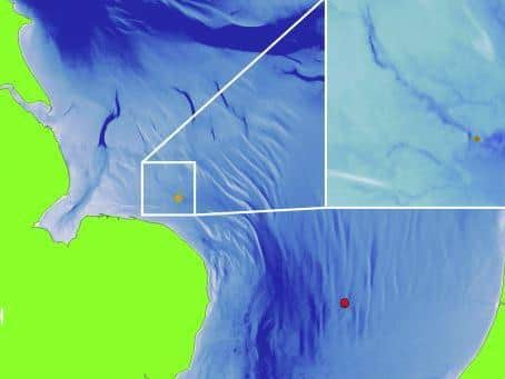
"You wouldn't be following mammoths or reindeer herds by this time," he said.
"These people had territories, they may have moved occasionally, to take advantage of what was happening in the forest.
"They would have had base camps and the estuary would have been somewhere to live. These places would have been very attractive - there's fresh water, fish, birds, shellfish.
"It makes life good for the hunter gatherer."
Over the years the team has built up a detailed map showing rivers, lakes, hills and coastlines in a country as large as Scotland which had previously been a heartland of human occupation in Europe.
Advertisement
Hide AdAdvertisement
Hide AdCores dropped into the seabed from ships bring up big tubes of sediment, which show clearly evidence of the ancient tsunami, which smashed into the shorelines of all the countries around the North Sea, in three great waves, 8,200 years ago.
The deposits from the tsunami - which were caused by a massive shift in the sea bed known as the Storegga Slide- are "full of smashed shell and DNA of trees", said Prof Gaffney.
Although not the end of Doggerland, the event must have been catastrophic, he said.
“Although many thousands of people must have lived on these drowned lands, the extreme nature of working in the North Sea means that archaeologists have never been able to locate a single human settlement in the vast landscape. Work at Bradford is changing how we understand this mysterious land beneath the sea and how it eventually ended.”
Comment Guidelines
National World encourages reader discussion on our stories. User feedback, insights and back-and-forth exchanges add a rich layer of context to reporting. Please review our Community Guidelines before commenting.